
Nor’easter #4? Another shot of snow, rain, wind, and surge for NJ
Since the middle of last week, we’ve been tracking yet another nor’easter — our fourth this March, for those keeping score. This one ironically arrives on the First Day of Spring, this Tuesday.
Social media has been buzzing with a lot of hype and a lot of guessing, amidst a deep swamp of forecast uncertainty. It’s been a challenging and frustrating few days, to say the least. With less than 48 hours to go before the first flakes fall, we’re finally getting some resolution on this storm’s forecast.
I hesitate to go into too much detail about the storm’s potential track and impacts, because there’s still tremendous room for the storm to “wiggle” and for this forecast to change. But I do want to present five generalized headlines to help you understand what to expect this week.
The setup is very complicated
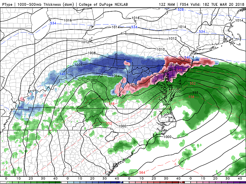
It’s actually two storms for the price of one! One area of low pressure is forecast to arrive from the west early Tuesday. A second system will dig further south, before sliding parallel to the Atlantic coast, arriving here on Wednesday. The timing of each, the tracks of each, and the temperatures before and during each storm system will all directly affect our weather impacts. That’s why models are struggling to come to a consensus, and why we have been unable to issue a specific forecast yet.
Both the GFS and NAM have now settled on a track and keeps the center of each storm system too far south and east of New Jersey to cause a direct hit. Notably, the Euro has shifted back toward a more significant impact, but it’s still generally a glancing blow. This forecast is indeed precarious, and a really close call.
This will be a prolonged, evolving weather event
A 36-hour snowstorm? Eh, kind of. Again, there could be two periods of steadier snow/sleet/rain on the way — currently forecast to occur around Tuesday morning and Wednesday morning. It’s going to be a long week in the weather center, with an extended period of messy travel and coastal conditions. More specifically, the window of expected sloppy weather will be between about 5 a.m. Tuesday through 5 p.m. Wednesday.
No snow bomb?
I’ll say it as straightforward as possible — I am leaning toward a not very snowy forecast. For those sick of wintry weather, limited snow potential and limited geography will be your friends. Additionally, it is unlikely that either of these storm systems will “bomb out” or rapidly intensify (like our January 3 and March 7 storms did, in quite dramatic fashion).
In terms of the forecast, let me give you three scenarios:
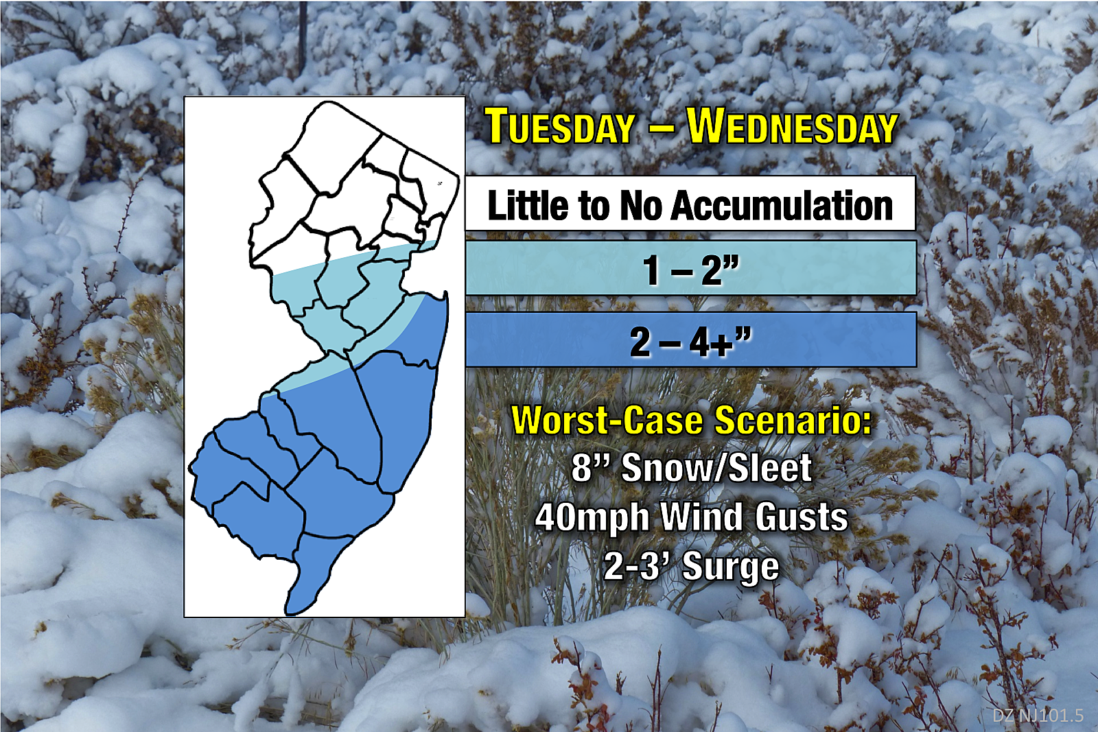
--Middle-ground, 2 to 4 inches… This is where models are pointing right now, and where my gut lies too. Again, southern and coastal NJ (let’s say along and south of I-195, and along and east of Route 9) could see light to moderate snow and sleet accumulations. North Jersey, unless something shifts dramatically, this ain’t your storm.
--Total miss, no snow… Yup, still a chance at a totally or mostly snow-free forecast! If both systems dig about 50 to 100 miles further south than anticipated, they would probably miss New Jersey completely. Even so, we’d still have clouds, wind, and coastal impacts. (And maybe some rain too.)
--Perfect storm, 8 inches... On the flip side, if the storm tracks realign further north and west, areas of southern and coastal NJ could see some pretty good snowfall throughout Tuesday and Wednesday. I’m backing off from the idea of “double-digit” snowfall totals in the worst-case scenario, but anything over a half-foot still qualifies as significant snow in my book.
In any of these three scenarios, wind gusts of 40+ are likely.
Coastal flooding will be a legitimate concern again
Apologies to the Jersey Shore, but here we go again. As you know, any time a center of low pressure passes close to the NJ coastline, it warrants a raised eyebrow or two.
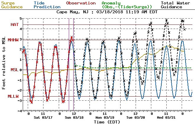
The latest tidal guidance shows 2 to 3 feet of storm surge, putting our coastal flood potential in the minor to moderate category during several successive high tide cycles. Water levels will begin rising on Tuesday, peak on Wednesday, and not subside until Thursday. The “usual spots” will probably see some water inundation, vulnerable roads will need to close again, and some property damage is possible too.
Don’t call this winter’s grand finale
I’ve said a few times that the Vernal Equinox — the First Day of Spring — is an important benchmark in the weather world. It’s right around this time of year that the Northeast U.S. naturally starts to warm up, thanks to the combination of a higher sun angle and limited influence of arctic air masses. While March is notorious for big snowstorms in New Jersey, April is not. So it’s safe to say that Ol’ Man Winter’s days are numbered.
However, models have consistently shown yet another storm system for the upcoming weekend, in the Saturday to early Sunday time frame. Not a nor’easter storm track this time around, which would thankfully limit any coastal impacts. But there’s still a good chance for a messy mix of snow and rain, with some potential for accumulation. (Although my earlier disclaimer regarding late-season snow storms applies.) Too soon to talk details, but also worth watching.
I expect to publish another weather blog update either Sunday evening or Monday morning with an updated snow map.
More From Cat Country 107.3


