
NJ Thanksgiving holiday weekend weather: Breezy, turning colder
The Bottom Line
As promised, it was a soggy, wind-swept night across New Jersey. Top rainfall totals ended up just above 2 inches across much of South Jersey. Most spots saw wind gusts exceed 30 mph, with top gusts of 49 mph at Sea Girt (Monmouth County) and Vernon (Sussex County). Thanks as always to the NJ Weather Climate at Rutgers for their great cache of data.
We are already doing better now, as heavy rain has exited and the ferocious gusts have subsided. You will have to watch out for puddles and even areas of flooding starting out Wednesday. And roads will be wet and slippery, especially when covered with leaves.
Beyond Wednesday morning, I do not anticipate any significant weather-related travel concerns for New Jersey. A brisk wind could impact parade balloons on Thanksgiving morning. We have two "little" shots of showers in the forecast: Wednesday evening and Sunday evening. And it will turn much colder — not necessarily for Thanksgiving Day, but you'll really feel the chill in the air for the rest of the holiday weekend.

Wednesday
Happy Thanksgiving Eve! For most of New Jersey, the rain is done at this point. Through about 8 or 9 a.m., some showers will affect the northern, eastern, and southern edges of the state only. And everyone in NJ could experience a sprinkle and some fog/mist in that same time frame.
By Wednesday afternoon, we should see peeks of sun statewide. Winds will be reasonable, around 15 mph. And temperatures stay on the mild side, reaching the upper 50s to around 60 degrees.
As a weak cold front pushes in Wednesday evening, a few spotty showers are possible. All rain, light and brief — overall, no big deal. Other than that, skies will continue to clear overnight. And we will stay above freezing, with lows only dipping into the lower 40s.
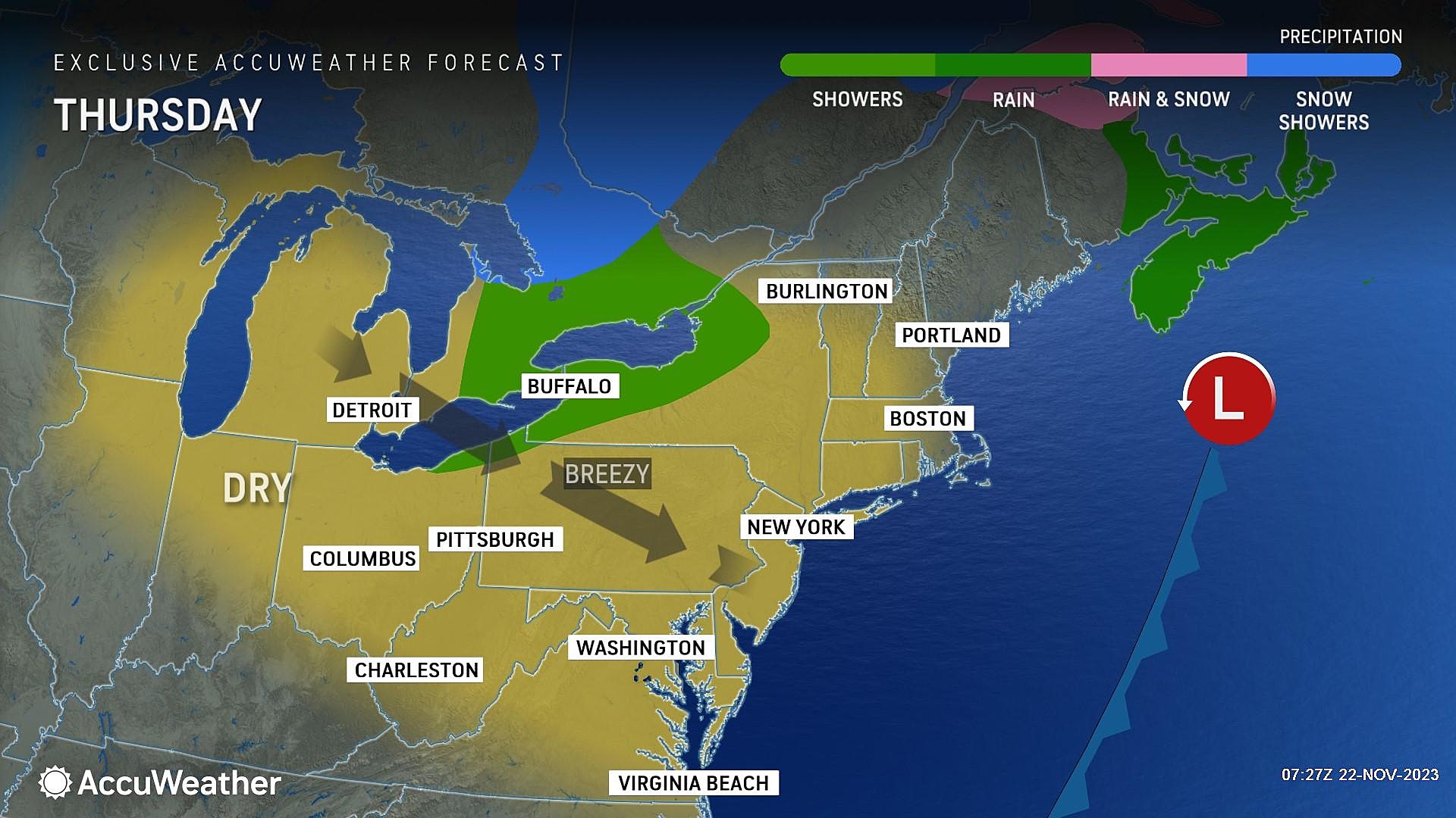
Thursday
Thanksgiving Day will look nice. And temperatures will be seasonable. But there is one little concern.
It is going to be breezy.
Generally, a stiff breeze does not cause problems. But the balloons in the Thanksgiving Day Parade have very strict limits about when they can fly at full height, and when they can't. I am seeing potential gusts up to 25 mph Thursday morning, which may cause some issues.
Otherwise, skies will turn mostly sunny. High temperatures will reach about 50 to 55 degrees. That is about par for the course for Thanksgiving — if the wind dies down a bit, it will actually be a pleasant afternoon.
Friday
A storm system will pass well south of New Jersey. Precipitation stays away, but we will see enhanced cloud cover.
And the cooldown continues. Some areas might freeze or frost Friday morning. High temperatures Friday afternoon will be limited to the mid 40s. Expect a stiff northwesterly breeze at times too, keeping it extra-chilly.
Saturday
Likely the coldest day of the week. Morning lows in the 20s — a deep freeze for most. Afternoon highs will only reach about 40 degrees. That is akin to a typical "dead of winter" late January day. Not very pleasant, although skies will offer partial sunshine, winds will stay light, and our weather and air will be bone dry.
Sunday & Beyond
The big "travel home" day on Sunday will cloud up again, as we hold on to below-normal temperatures in the mid 40s.
Forecast models are suggesting a batch of showers will push across New Jersey Sunday evening. It doesn't look like a big deal, although I can't rule out some snowflakes to the northwest. If you do have travel plans at the tail-end of the weekend, it may be worthwhile to keep an eye on the latest forecast.
Temperatures will likely stay below-normal (sub 50 degrees) through the start of December. The next opportunity for a significant storm system is about 10 days away, at the end of next week.
LOOK: Here Are the 25 Best Thanksgiving movies of all time
Dan Zarrow is Chief Meteorologist for Townsquare Media New Jersey. Follow him on Facebook for the latest forecast and realtime weather updates.
LOOK: Food history from the year you were born
Gallery Credit: Joni Sweet
More From Cat Country 107.3