
Snow, wind, flooding: County-by-county breakdown of NJ nor’easter impacts
The Latest Update
A powerful and potentially historic coastal storm — a nor'easter — arrives in New Jersey on Sunday, with effects lingering throughout Monday too. The next 36 hours are going to turn wintry and treacherous, as we face our 11th winter storm of the 2025-26 season. And the most significant in several years.
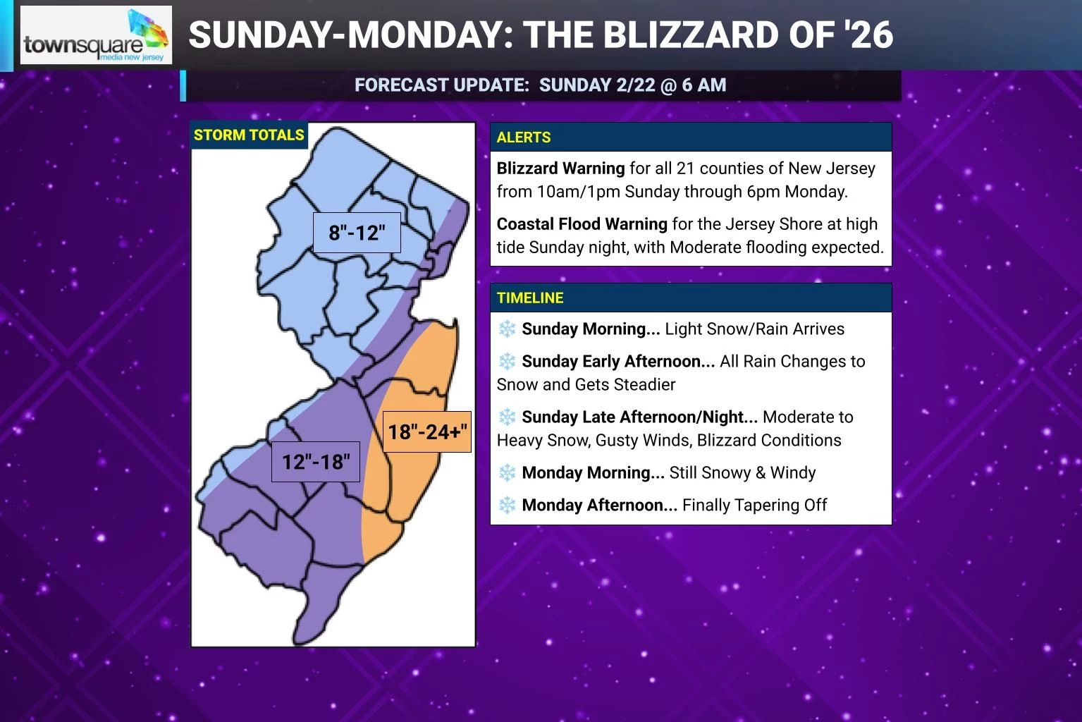
There are no wholesale changes to report in the forecast. Everything is holding strong, and pointing to one heck of a storm. And some of that model guidance is pretty scary, and even record-breaking — the NAM has shown as much 42" of snow for part of the Jersey Shore by Monday. (For many reasons — mixing, subsidence, dry-slotting, too much moisture, too cold temperatures — I think that number is preposterous. But it is amazing how consistent these models have been in pumping out some huge snowfall numbers.)
I want to focus on the three big impacts from our impending nor'easter:
1.) Heavy snow, which will be measured in feet rather than inches for part of New Jersey, leading to significant, prolonged travel disruptions statewide.
2.) Wind, with top gusts in the 40 to 60 mph range.
3.) Coastal flooding, driven by #2, and expected to crest in the Moderate category during Sunday night's high tide cycle.
Of course, the combination of heavy snow and fierce winds lead to blizzard conditions. The Blizzard Warning has been expanded to now include all 21 counties of New Jersey, in effect from midday Sunday through Monday evening. Near-zero visibility will make travel conditions very dangerous if not impossible.
I did make some tweaks to my final forecast map — not necessarily because the forecast itself has changed, but in an attempt to more accurately and effectively communicate the picture of this storm that I have in my head.
Overall, I think "about a foot of snow" is a good estimate along the NJ Turnpike corridor between Philadelphia and New York — that line was literally the basis I used to draw this map. And I did bump up part of the Jersey Shore to 18 to 24+ inches of snow accumulation.
Make no mistake: Everyone in New Jersey is going to see a lot of snow and wind from this thing. It's just a matter of how deeply you are going to be buried, and therefore how long it is going to take to dig out.
COUNTY-BY-COUNTY BREAKDOWN
For the rest of this article, I am going to do my traditional "county by county" breakdown of the forecast. For the record, these summaries are NOT AI-generated — I type them myself into Excel, with some cut-and-paste for similar counties and zones. Hopefully this level of detail helps you understand the nuances of my forecast, and helps you plan the next two days and stay safe.
Atlantic County
Storm Total Snowfall... 12 to 18 inches west of Mays Landing, 18 to 24 inches closer to the coast
Top Wind Gusts... 50 to 60 mph
Temperatures / Wind Chills... Temperatures will fall from the upper 30s Sunday morning into the 20s by Sunday night. Biting wind chills in the teens are possible into Monday morning.
Coastal Flooding Category... Moderate Sunday night (3 to 4 foot surge), Minor to Moderate Monday afternoon (3 foot surge)
Start Timing... Spotty rain showers arrive Sunday morning, changing to wintry mix and then all snow by early afternoon. Snow will quickly become steadier this afternoon too. Expect snow to stick to the ground and start accumulating by late afternoon.
Brunt Timing... Bands of heavy snow will pound New Jersey from Sunday late afternoon through early Monday morning. Snowfall rates of 1 to 2+ inches per hour are possible. Combined with strong winds, blizzard (near whiteout) conditions are possible overnight.
End Timing... Monday early morning will remain snowy and windy, with blizzard conditions and accumulations continuing. The commute will be terrible, and there will be widespread school closings. Snow intensity will slowly dial back by late morning. Snow will finally taper off around late afternoon.
Blizzard Warning... 1 p.m. Sunday to 6 p.m. Monday, cautioning that travel will be dangerous if not impossible due to near-zero visibility and slick conditions
Coastal Flood Warning... 9 p.m. Sunday to 5 a.m. Monday (may be extended, as needed)
Bottom Line... This will be one of the most significant, impactful winter storms in years at the Jersey Shore. The combination of heavy snow and fierce winds will make for treacherous travel conditions for a prolonged period from Sunday afternoon through Monday morning. Making matters worse are the threats for wind-driven power outages and coastal flooding. Hunker down and be prepared for a long, slow cleanup of deep, dense snow this week.
Bergen County
Storm Total Snowfall... About a foot (12 inches)
Top Wind Gusts... 50 to 60 mph
Temperatures / Wind Chills... Temperatures will fall from the lower 30s Sunday morning into the 20s by Sunday night. Biting wind chills in the teens are possible into Monday morning.
Coastal Flooding Category... Moderate Sunday night (2 to 4 foot surge), Spotty Minor Monday afternoon (2 to 3 foot surge)
Start Timing... Spotty snow showers arrive Sunday morning, becoming steadier by early afternoon. Snow will likely start to stick to the ground by about lunchtime.
Brunt Timing... Expect bands of moderate to heavy snow Sunday evening and overnight, with snowfall rates possibly exceeding 1 to 2 inches per hour. Gusty winds will kick up too. Not only will road conditions be poor, but visibility could be near-zero due to falling and blowing snow.
End Timing... Monday early morning will remain snowy and windy, with blizzard conditions and accumulations continuing. The commute will be terrible, and there will be widespread school closings. Snow intensity will slowly dial back by late morning. Snow will finally taper off around late afternoon.
Blizzard Warning... 1 p.m. Sunday to 6 p.m. Monday, cautioning that travel will be dangerous if not impossible due to near-zero visibility and slick conditions
Coastal Flood Warning... 10 p.m. Sunday to 2 a.m. Monday (may be extended, as needed))
Bottom Line... It has already been a crazy winter, and Mother Nature is piling on with potential blizzard conditions. The combination of heavy snow and gusty winds is nasty business, making for hazardous road conditions in our already congested and challenging travel corridor. Hopefully you can hunker down for the worst of the storm. And hopefully you are ready for some serious storm clean-up come Monday morning, as this snow is going to be deep, heavy, and wet.
Burlington County
Storm Total Snowfall... 12 to 18 inches, totals could be higher (closer to 24 inches) to the southeast near the coast
Top Wind Gusts... 40 to 50 mph
Temperatures / Wind Chills... Temperatures will fall from the mid 30s Sunday morning into the 20s by Sunday night. Biting wind chills in the teens are possible into Monday morning.
Coastal Flooding Category... Moderate Sunday night (3 to 4 foot surge), Minor to Moderate Monday afternoon (3 foot surge)
Start Timing... Spotty rain showers arrive Sunday morning, changing to wintry mix and then all snow by early afternoon. Snow will quickly become steadier this afternoon too. Expect snow to stick to the ground and start accumulating by mid to late afternoon.
Brunt Timing... Bands of moderate to heavy snow will develop from Sunday late afternoon through Sunday night, lingering into Monday morning, accumulating quickly on the ground. Road conditions will be poor overnight, and visibility will be very low due to falling and blowing snow.
End Timing... Monday early morning will remain snowy and windy, with blizzard conditions and accumulations continuing. The commute will be terrible, and there will be widespread school closings. Snow intensity will slowly dial back by late morning. Snow will finally taper off around late morning.
Blizzard Warning... 10 a.m. Sunday to 6 p.m. Monday, cautioning that travel will be dangerous if not impossible due to near-zero visibility and slick conditions
Coastal Flood Warning... 9 p.m. Sunday to 5 a.m. Monday (may be extended, as needed)
Bottom Line... While snow totals and wind speeds will be slightly lower here than at the Jersey Shore, this will still be one nasty winter storm. Snow will pile up quickly and the wind will howl for several hours Sunday night through Monday morning. Be ready to shovel some deep, heavy snow. School closings are practically a certainty on Monday.
Camden County
Storm Total Snowfall... 12 to 18 inches
Top Wind Gusts... 40 to 50 mph
Temperatures / Wind Chills... Temperatures will fall from the mid 30s Sunday morning into the 20s by Sunday night. Biting wind chills in the teens are possible into Monday morning.
Start Timing... Spotty rain showers arrive Sunday morning, changing to wintry mix and then all snow by early afternoon. Snow will quickly become steadier this afternoon too. Expect snow to stick to the ground and start accumulating by mid to late afternoon.
Brunt Timing... Bands of moderate to heavy snow will develop from Sunday late afternoon through Sunday night, lingering into Monday morning, accumulating quickly on the ground. Road conditions will be poor overnight, and visibility will be very low due to falling and blowing snow.
End Timing... Monday early morning will remain snowy and windy, with blizzard conditions and accumulations continuing. The commute will be terrible, and there will be widespread school closings. Snow intensity will slowly dial back by late morning. Snow will finally taper off around late morning.
Blizzard Warning... 10 a.m. Sunday to 6 p.m. Monday, cautioning that travel will be dangerous if not impossible due to near-zero visibility and slick conditions
Bottom Line... While snow totals and wind speeds will be slightly lower here than at the Jersey Shore, this will still be one nasty winter storm. Snow will pile up quickly and the wind will howl for several hours Sunday night through Monday morning. Be ready to shovel some deep, heavy snow. School closings are practically a certainty on Monday.
Cape May County
Storm Total Snowfall... 12 to 18 inches
Top Wind Gusts... 50 to 60 mph
Temperatures / Wind Chills... Temperatures will fall from the upper 30s Sunday morning into the 20s by Sunday night. Biting wind chills in the teens are possible into Monday morning.
Coastal Flooding Category... Moderate Sunday night (3 to 4 foot surge), Minor to Moderate Monday afternoon (3 foot surge)
Start Timing... Spotty rain showers arrive Sunday morning, changing to wintry mix and then all snow by early afternoon. Snow will quickly become steadier this afternoon too. Expect snow to stick to the ground and start accumulating by late afternoon.
Brunt Timing... Bands of heavy snow will pound New Jersey from Sunday late afternoon through early Monday morning. Snowfall rates of 1 to 2+ inches per hour are possible. Combined with strong winds, blizzard (near whiteout) conditions are possible overnight.
End Timing... Monday early morning will remain snowy and windy, with blizzard conditions and accumulations continuing. The commute will be terrible, and there will be widespread school closings. Snow intensity will slowly dial back by late morning. Snow will finally taper off around late afternoon.
Blizzard Warning... 1 p.m. Sunday to 6 p.m. Monday, cautioning that travel will be dangerous if not impossible due to near-zero visibility and slick conditions
Coastal Flood Warning... 9 p.m. Sunday to 5 a.m. Monday (may be extended, as needed)
Bottom Line... This will be one of the most significant, impactful winter storms in years at the Jersey Shore. The combination of heavy snow and fierce winds will make for treacherous travel conditions for a prolonged period from Sunday afternoon through Monday morning. Making matters worse are the threats for wind-driven power outages and coastal flooding. Hunker down and be prepared for a long, slow cleanup of deep, dense snow this week.
Cumberland County
Storm Total Snowfall... 12 to 18 inches
Top Wind Gusts... 50 to 60 mph
Temperatures / Wind Chills... Temperatures will fall from the upper 30s Sunday morning into the 20s by Sunday night. Biting wind chills in the teens are possible into Monday morning.
Start Timing... Spotty rain showers arrive Sunday morning, changing to wintry mix and then all snow by early afternoon. Snow will quickly become steadier this afternoon too. Expect snow to stick to the ground and start accumulating by late afternoon.
Brunt Timing... Bands of moderate to heavy snow are expected from Sunday late afternoon through early Monday morning. Snowfall rates of 1 to 2 inches an hour are possible. Combined with strong winds, blizzard (near whiteout) conditions are possible overnight.
End Timing... Monday early morning will remain snowy and windy, with blizzard conditions and accumulations continuing. The commute will be terrible, and there will be widespread school closings. Snow intensity will slowly dial back by late morning. Snow will finally taper off around late afternoon.
Blizzard Warning... 10 a.m. Sunday to 6 p.m. Monday, cautioning that travel will be dangerous if not impossible due to near-zero visibility and slick conditions
Bottom Line... This will be one of the most significant, impactful winter storms in years at the Jersey Shore. The combination of heavy snow and fierce winds will make for treacherous travel conditions for a prolonged period from Sunday afternoon through Monday morning. Making matters worse are the threats for wind-driven power outages and coastal flooding. Hunker down and be prepared for a long, slow cleanup of deep, dense snow this week.
Essex County
Storm Total Snowfall... About a foot (12 inches)
Top Wind Gusts... 50 to 60 mph
Temperatures / Wind Chills... Temperatures will fall from the mid 30s Sunday morning into the 20s by Sunday night. Biting wind chills in the teens are possible into Monday morning.
Coastal Flooding Category... Moderate Sunday night (2 to 4 foot surge), Spotty Minor Monday afternoon (2 to 3 foot surge)
Start Timing... Spotty snow showers arrive Sunday morning, becoming steadier by early afternoon. Snow will likely start to stick to the ground by about lunchtime.
Brunt Timing... Expect bands of moderate to heavy snow Sunday evening and overnight, with snowfall rates possibly exceeding 1 to 2 inches per hour. Gusty winds will kick up too. Not only will road conditions be poor, but visibility could be near-zero due to falling and blowing snow.
End Timing... Monday early morning will remain snowy and windy, with blizzard conditions and accumulations continuing. The commute will be terrible, and there will be widespread school closings. Snow intensity will slowly dial back by late morning. Snow will finally taper off around late afternoon.
Blizzard Warning... 1 p.m. Sunday to 6 p.m. Monday, cautioning that travel will be dangerous if not impossible due to near-zero visibility and slick conditions
Coastal Flood Warning... 10 p.m. Sunday to 2 a.m. Monday (may be extended, as needed))
Bottom Line... It has already been a crazy winter, and Mother Nature is piling on with potential blizzard conditions. The combination of heavy snow and gusty winds is nasty business, making for hazardous road conditions in our already congested and challenging travel corridor. Hopefully you can hunker down for the worst of the storm. And hopefully you are ready for some serious storm clean-up come Monday morning, as this snow is going to be deep, heavy, and wet.
Gloucester County
Storm Total Snowfall... 12 to 18 inches
Top Wind Gusts... 40 to 50 mph
Temperatures / Wind Chills... Temperatures will fall from the mid 30s Sunday morning into the 20s by Sunday night. Biting wind chills in the teens are possible into Monday morning.
Start Timing... Spotty rain showers arrive Sunday morning, changing to wintry mix and then all snow by early afternoon. Snow will quickly become steadier this afternoon too. Expect snow to stick to the ground and start accumulating by late afternoon.
Brunt Timing... Bands of moderate to heavy snow will develop from Sunday late afternoon through Sunday night, lingering into Monday morning, accumulating quickly on the ground. Road conditions will be poor overnight, and visibility will be very low due to falling and blowing snow.
End Timing... Monday early morning will remain snowy and windy, with blizzard conditions and accumulations continuing. The commute will be terrible, and there will be widespread school closings. Snow intensity will slowly dial back by late morning. Snow will finally taper off around late morning.
Blizzard Warning... 10 a.m. Sunday to 6 p.m. Monday, cautioning that travel will be dangerous if not impossible due to near-zero visibility and slick conditions
Bottom Line... While snow totals and wind speeds will be slightly lower here than at the Jersey Shore, this will still be one nasty winter storm. Snow will pile up quickly and the wind will howl for several hours Sunday night through Monday morning. Be ready to shovel some deep, heavy snow. School closings are practically a certainty on Monday.
Hudson County
Storm Total Snowfall... 12 to 18 inches
Top Wind Gusts... 50 to 60 mph
Temperatures / Wind Chills... Temperatures will fall from the mid 30s Sunday morning into the 20s by Sunday night. Biting wind chills in the teens are possible into Monday morning.
Coastal Flooding Category... Moderate Sunday night (2 to 4 foot surge), Spotty Minor Monday afternoon (2 to 3 foot surge)
Start Timing... Spotty snow showers arrive Sunday morning, becoming steadier by early afternoon. Snow will likely start to stick to the ground by about lunchtime.
Brunt Timing... Expect bands of moderate to heavy snow Sunday evening and overnight, with snowfall rates possibly exceeding 1 to 2 inches per hour. Gusty winds will kick up too. Not only will road conditions be poor, but visibility could be near-zero due to falling and blowing snow.
End Timing... Monday early morning will remain snowy and windy, with blizzard conditions and accumulations continuing. The commute will be terrible, and there will be widespread school closings. Snow intensity will slowly dial back by late morning. Snow will finally taper off around late afternoon.
Blizzard Warning... 1 p.m. Sunday to 6 p.m. Monday, cautioning that travel will be dangerous if not impossible due to near-zero visibility and slick conditions
Coastal Flood Warning... 10 p.m. Sunday to 2 a.m. Monday (may be extended, as needed))
Bottom Line... It has already been a crazy winter, and Mother Nature is piling on with potential blizzard conditions. The combination of heavy snow and gusty winds is nasty business, making for hazardous road conditions in our already congested and challenging travel corridor. Hopefully you can hunker down for the worst of the storm. And hopefully you are ready for some serious storm clean-up come Monday morning, as this snow is going to be deep, heavy, and wet.
Hunterdon County
Storm Total Snowfall... 8 to 12 inches
Top Wind Gusts... 40 to 50 mph
Temperatures / Wind Chills... Temperatures will fall from the mid 30s Sunday morning into the 20s by Sunday night. Biting wind chills in the teens are possible into Monday morning.
Start Timing... Spotty snow showers arrive Sunday morning, becoming steadier by early afternoon. Snow will likely start to stick to the ground by about lunchtime.
Brunt Timing... Moderate intensity snow will pick up Sunday evening and overnight, possibly exceeding an inch an hour at times. A gusty wind will kick up as well, further reducing visibility and adding a biting wind chill to the air. Travel conditions will be treacherous through Monday morning.
End Timing... Monday early morning will remain snowy and windy, with light accumulations continuing. The commute will be terrible, and there will be widespread school closings. Snow intensity will slowly dial back by late morning. Snow will finally taper off around midday.
Blizzard Warning... 10 a.m. Sunday to 6 p.m. Monday, cautioning that travel will be dangerous if not impossible due to near-zero visibility and slick conditions
Bottom Line... Farthest from the center of this nasty nor'easter, the northwest corner of the state will see some of the lowest snow totals in New Jersey. However, this forecast still falls in the "major impacts" category, especially when moderate to heavy snow combines with gusty winds. Get ready for an extended period of wintry weather and difficult travel conditions, followed by a lot of plowing and shoveling.
Mercer County
Storm Total Snowfall... About a foot (12 inches)
Top Wind Gusts... 40 to 50 mph
Temperatures / Wind Chills... Temperatures will fall from the mid 30s Sunday morning into the 20s by Sunday night. Biting wind chills in the teens are possible into Monday morning.
Start Timing... Spotty snow and rain showers arrive Sunday morning. Wintry mix will change over to all snow by early afternoon, and also become steadier. Snow will likely start to stick to the ground by mid-afternoon.
Brunt Timing... Bands of moderate to heavy snow will develop from Sunday late afternoon through Sunday night, lingering into Monday morning, accumulating quickly on the ground. Road conditions will be poor overnight, and visibility will be very low due to falling and blowing snow.
End Timing... Monday early morning will remain snowy and windy, with blizzard conditions and accumulations continuing. The commute will be terrible, and there will be widespread school closings. Snow intensity will slowly dial back by late morning. Snow will finally taper off around late morning.
Blizzard Warning... 10 a.m. Sunday to 6 p.m. Monday, cautioning that travel will be dangerous if not impossible due to near-zero visibility and slick conditions
Bottom Line... While snow totals and wind speeds will be slightly lower here than at the Jersey Shore, this will still be one nasty winter storm. Snow will pile up quickly and the wind will howl for several hours Sunday night through Monday morning. Be ready to shovel some deep, heavy snow. School closings are practically a certainty on Monday.
Middlesex County
Storm Total Snowfall... About a foot (12 inches)
Top Wind Gusts... 40 to 50 mph
Temperatures / Wind Chills... Temperatures will fall from the mid 30s Sunday morning into the 20s by Sunday night. Biting wind chills in the teens are possible into Monday morning.
Coastal Flooding Category... Moderate Sunday night (3 to 4 foot surge), Minor Monday afternoon (3 foot surge)
Start Timing... Spotty snow and rain showers arrive Sunday morning. Wintry mix will change over to all snow by early afternoon, and also become steadier. Snow will likely start to stick to the ground by mid-afternoon.
Brunt Timing... Bands of moderate to heavy snow are expected from Sunday late afternoon through early Monday morning. Snowfall rates of 1 to 2 inches an hour are possible. Combined with strong winds, blizzard (near whiteout) conditions are possible overnight.
End Timing... Monday early morning will remain snowy and windy, with blizzard conditions and accumulations continuing. The commute will be terrible, and there will be widespread school closings. Snow intensity will slowly dial back by late morning. Snow will finally taper off around early afternoon.
Blizzard Warning... 10 a.m. Sunday to 6 p.m. Monday, cautioning that travel will be dangerous if not impossible due to near-zero visibility and slick conditions
Coastal Flood Warning... 9 p.m. Sunday to 5 a.m. Monday (may be extended, as needed)
Bottom Line... While snow totals and wind speeds will be slightly lower here than at the Jersey Shore, this will still be one nasty winter storm. Snow will pile up quickly and the wind will howl for several hours Sunday night through Monday morning. Be ready to shovel some deep, heavy snow. School closings are practically a certainty on Monday.
Monmouth County
Storm Total Snowfall... 18 to 24+ inches for most, slightly less west of the Route 9 corridor
Top Wind Gusts... 50 to 60 mph
Temperatures / Wind Chills... Temperatures will fall from the mid 30s Sunday morning into the 20s by Sunday night. Biting wind chills in the teens are possible into Monday morning.
Coastal Flooding Category... Moderate Sunday night (3 to 4 foot surge), Minor Monday afternoon (3 foot surge)
Start Timing... Spotty snow and rain showers arrive Sunday morning. Wintry mix will change over to all snow by early afternoon, and also become steadier. Snow will likely start to stick to the ground by mid-afternoon.
Brunt Timing... Bands of heavy snow will pound New Jersey from Sunday late afternoon through early Monday morning. Snowfall rates of 1 to 2+ inches per hour are possible. Combined with strong winds, blizzard (near whiteout) conditions are possible overnight.
End Timing... Monday early morning will remain snowy and windy, with blizzard conditions and accumulations continuing. The commute will be terrible, and there will be widespread school closings. Snow intensity will slowly dial back by late morning. Snow will finally taper off around late afternoon.
Blizzard Warning... 10 a.m. Sunday to 6 p.m. Monday, cautioning that travel will be dangerous if not impossible due to near-zero visibility and slick conditions
Coastal Flood Warning... 9 p.m. Sunday to 5 a.m. Monday (may be extended, as needed)
Bottom Line... This will be one of the most significant, impactful winter storms in years at the Jersey Shore. The combination of heavy snow and fierce winds will make for treacherous travel conditions for a prolonged period from Sunday afternoon through Monday morning. Making matters worse are the threats for wind-driven power outages and coastal flooding. Hunker down and be prepared for a long, slow cleanup of deep, dense snow this week.
Morris County
Storm Total Snowfall... 8 to 12 inches
Top Wind Gusts... 40 to 50 mph
Temperatures / Wind Chills... Temperatures will fall from the lower 30s Sunday morning into the 20s by Sunday night. Biting wind chills in the teens are possible into Monday morning.
Start Timing... Spotty snow showers arrive Sunday morning, becoming steadier by early afternoon. Snow will likely start to stick to the ground by about lunchtime.
Brunt Timing... Moderate intensity snow will pick up Sunday evening and overnight, possibly exceeding an inch an hour at times. A gusty wind will kick up as well, further reducing visibility and adding a biting wind chill to the air. Travel conditions will be treacherous through Monday morning.
End Timing... Monday early morning will remain snowy and windy, with light accumulations continuing. The commute will be terrible, and there will be widespread school closings. Snow intensity will slowly dial back by late morning. Snow will finally taper off around midday.
Blizzard Warning... 10 a.m. Sunday to 6 p.m. Monday, cautioning that travel will be dangerous if not impossible due to near-zero visibility and slick conditions
Bottom Line... Farthest from the center of this nasty nor'easter, the northwest corner of the state will see some of the lowest snow totals in New Jersey. However, this forecast still falls in the "major impacts" category, especially when moderate to heavy snow combines with gusty winds. Get ready for an extended period of wintry weather and difficult travel conditions, followed by a lot of plowing and shoveling.
Ocean County
Storm Total Snowfall... 18 to 24+ inches
Top Wind Gusts... 50 to 60 mph
Temperatures / Wind Chills... Temperatures will fall from the mid 30s Sunday morning into the 20s by Sunday night. Biting wind chills in the teens are possible into Monday morning.
Coastal Flooding Category... Moderate Sunday night (3 to 4 foot surge), Minor to Moderate Monday afternoon (3 foot surge)
Start Timing... Spotty rain showers arrive Sunday morning, changing to wintry mix and then all snow by early afternoon. Snow will quickly become steadier this afternoon too. Expect snow to stick to the ground and start accumulating by mid to late afternoon.
Brunt Timing... Bands of heavy snow will pound New Jersey from Sunday late afternoon through early Monday morning. Snowfall rates of 1 to 2+ inches per hour are possible. Combined with strong winds, blizzard (near whiteout) conditions are possible overnight.
End Timing... Monday early morning will remain snowy and windy, with blizzard conditions and accumulations continuing. The commute will be terrible, and there will be widespread school closings. Snow intensity will slowly dial back by late morning. Snow will finally taper off around late afternoon.
Blizzard Warning... 10 a.m. Sunday to 6 p.m. Monday, cautioning that travel will be dangerous if not impossible due to near-zero visibility and slick conditions
Coastal Flood Warning... 9 p.m. Sunday to 5 a.m. Monday (may be extended, as needed)
Bottom Line... This will be one of the most significant, impactful winter storms in years at the Jersey Shore. The combination of heavy snow and fierce winds will make for treacherous travel conditions for a prolonged period from Sunday afternoon through Monday morning. Making matters worse are the threats for wind-driven power outages and coastal flooding. Hunker down and be prepared for a long, slow cleanup of deep, dense snow this week.
Passaic County
Storm Total Snowfall... 10 to 12 inches
Top Wind Gusts... 50 to 60 mph
Temperatures / Wind Chills... Temperatures will fall from the lower 30s Sunday morning into the 20s by Sunday night. Biting wind chills in the teens are possible into Monday morning.
Start Timing... Spotty snow showers arrive Sunday morning, becoming steadier by early afternoon. Snow will likely start to stick to the ground by about lunchtime.
Brunt Timing... Expect bands of moderate to heavy snow Sunday evening and overnight, with snowfall rates possibly exceeding 1 to 2 inches per hour. Gusty winds will kick up too. Not only will road conditions be poor, but visibility could be near-zero due to falling and blowing snow.
End Timing... Monday early morning will remain snowy and windy, with blizzard conditions and accumulations continuing. The commute will be terrible, and there will be widespread school closings. Snow intensity will slowly dial back by late morning. Snow will finally taper off around late afternoon.
Blizzard Warning... 1 p.m. Sunday to 6 p.m. Monday, cautioning that travel will be dangerous if not impossible due to near-zero visibility and slick conditions
Bottom Line... It has already been a crazy winter, and Mother Nature is piling on with potential blizzard conditions. The combination of heavy snow and gusty winds is nasty business, making for hazardous road conditions in our already congested and challenging travel corridor. Hopefully you can hunker down for the worst of the storm. And hopefully you are ready for some serious storm clean-up come Monday morning, as this snow is going to be deep, heavy, and wet.
Salem County
Storm Total Snowfall... 12 to 18 inches
Top Wind Gusts... 40 to 50 mph
Temperatures / Wind Chills... Temperatures will fall from the upper 30s Sunday morning into the 20s by Sunday night. Biting wind chills in the teens are possible into Monday morning.
Start Timing... Spotty rain showers arrive Sunday morning, changing to wintry mix and then all snow by early afternoon. Snow will quickly become steadier this afternoon too. Expect snow to stick to the ground and start accumulating by late afternoon.
Brunt Timing... Bands of moderate to heavy snow will develop from Sunday late afternoon through Sunday night, lingering into Monday morning, accumulating quickly on the ground. Road conditions will be poor overnight, and visibility will be very low due to falling and blowing snow.
End Timing... Monday early morning will remain snowy and windy, with blizzard conditions and accumulations continuing. The commute will be terrible, and there will be widespread school closings. Snow intensity will slowly dial back by late morning. Snow will finally taper off around late morning.
Blizzard Warning... 10 a.m. Sunday to 6 p.m. Monday, cautioning that travel will be dangerous if not impossible due to near-zero visibility and slick conditions
Bottom Line... While snow totals and wind speeds will be slightly lower here than at the Jersey Shore, this will still be one nasty winter storm. Snow will pile up quickly and the wind will howl for several hours Sunday night through Monday morning. Be ready to shovel some deep, heavy snow. School closings are practically a certainty on Monday.
Somerset County
Storm Total Snowfall... 10 to 12 inches
Top Wind Gusts... 40 to 50 mph
Temperatures / Wind Chills... Temperatures will fall from the mid 30s Sunday morning into the 20s by Sunday night. Biting wind chills in the teens are possible into Monday morning.
Start Timing... Spotty snow and rain showers arrive Sunday morning. Wintry mix will change over to all snow by early afternoon, and also become steadier. Snow will likely start to stick to the ground by mid-afternoon.
Brunt Timing... Bands of moderate to heavy snow will develop from Sunday late afternoon through Sunday night, lingering into Monday morning, accumulating quickly on the ground. Road conditions will be poor overnight, and visibility will be very low due to falling and blowing snow.
End Timing... Monday early morning will remain snowy and windy, with blizzard conditions and accumulations continuing. The commute will be terrible, and there will be widespread school closings. Snow intensity will slowly dial back by late morning. Snow will finally taper off around early afternoon.
Blizzard Warning... 10 a.m. Sunday to 6 p.m. Monday, cautioning that travel will be dangerous if not impossible due to near-zero visibility and slick conditions
Bottom Line... While snow totals and wind speeds will be slightly lower here than at the Jersey Shore, this will still be one nasty winter storm. Snow will pile up quickly and the wind will howl for several hours Sunday night through Monday morning. Be ready to shovel some deep, heavy snow. School closings are practically a certainty on Monday.
Sussex County
Storm Total Snowfall... 8 to 12 inches
Top Wind Gusts... 40 to 50 mph
Temperatures / Wind Chills... Temperatures will fall from the lower 30s Sunday morning into the 20s by Sunday night. Biting wind chills in the teens are possible into Monday morning.
Start Timing... Spotty snow showers arrive Sunday morning, becoming steadier by early afternoon. Snow will likely start to stick to the ground by about lunchtime.
Brunt Timing... Moderate intensity snow will pick up Sunday evening and overnight, possibly exceeding an inch an hour at times. A gusty wind will kick up as well, further reducing visibility and adding a biting wind chill to the air. Travel conditions will be treacherous through Monday morning.
End Timing... Monday early morning will remain snowy and windy, with light accumulations continuing. The commute will be terrible, and there will be widespread school closings. Snow intensity will slowly dial back by late morning. Snow will finally taper off around midday.
Blizzard Warning... 10 a.m. Sunday to 6 p.m. Monday, cautioning that travel will be dangerous if not impossible due to near-zero visibility and slick conditions
Bottom Line... Farthest from the center of this nasty nor'easter, the northwest corner of the state will see some of the lowest snow totals in New Jersey. However, this forecast still falls in the "major impacts" category, especially when moderate to heavy snow combines with gusty winds. Get ready for an extended period of wintry weather and difficult travel conditions, followed by a lot of plowing and shoveling.
Union County
Storm Total Snowfall... About a foot (12 inches)
Top Wind Gusts... 50 to 60 mph
Temperatures / Wind Chills... Temperatures will fall from the mid 30s Sunday morning into the 20s by Sunday night. Biting wind chills in the teens are possible into Monday morning.
Coastal Flooding Category... Moderate Sunday night (2 to 4 foot surge), Spotty Minor Monday afternoon (2 to 3 foot surge)
Start Timing... Spotty snow showers arrive Sunday morning, becoming steadier by early afternoon. Snow will likely start to stick to the ground by about lunchtime.
Brunt Timing... Expect bands of moderate to heavy snow Sunday evening and overnight, with snowfall rates possibly exceeding 1 to 2 inches per hour. Gusty winds will kick up too. Not only will road conditions be poor, but visibility could be near-zero due to falling and blowing snow.
End Timing... Monday early morning will remain snowy and windy, with blizzard conditions and accumulations continuing. The commute will be terrible, and there will be widespread school closings. Snow intensity will slowly dial back by late morning. Snow will finally taper off around late afternoon.
Blizzard Warning... 1 p.m. Sunday to 6 p.m. Monday, cautioning that travel will be dangerous if not impossible due to near-zero visibility and slick conditions
Coastal Flood Warning... 10 p.m. Sunday to 2 a.m. Monday (may be extended, as needed))
Bottom Line... It has already been a crazy winter, and Mother Nature is piling on with potential blizzard conditions. The combination of heavy snow and gusty winds is nasty business, making for hazardous road conditions in our already congested and challenging travel corridor. Hopefully you can hunker down for the worst of the storm. And hopefully you are ready for some serious storm clean-up come Monday morning, as this snow is going to be deep, heavy, and wet.
Warren County
Storm Total Snowfall... 8 to 12 inches
Top Wind Gusts... 40 to 50 mph
Temperatures / Wind Chills... Temperatures will fall from the lower 30s Sunday morning into the 20s by Sunday night. Biting wind chills in the teens are possible into Monday morning.
Start Timing... Spotty snow showers arrive Sunday morning, becoming steadier by early afternoon. Snow will likely start to stick to the ground by about lunchtime.
Brunt Timing... Moderate intensity snow will pick up Sunday evening and overnight, possibly exceeding an inch an hour at times. A gusty wind will kick up as well, further reducing visibility and adding a biting wind chill to the air. Travel conditions will be treacherous through Monday morning.
End Timing... Monday early morning will remain snowy and windy, with light accumulations continuing. The commute will be terrible, and there will be widespread school closings. Snow intensity will slowly dial back by late morning. Snow will finally taper off around midday.
Blizzard Warning... 10 a.m. Sunday to 6 p.m. Monday, cautioning that travel will be dangerous if not impossible due to near-zero visibility and slick conditions
Bottom Line... Farthest from the center of this nasty nor'easter, the northwest corner of the state will see some of the lowest snow totals in New Jersey. However, this forecast still falls in the "major impacts" category, especially when moderate to heavy snow combines with gusty winds. Get ready for an extended period of wintry weather and difficult travel conditions, followed by a lot of plowing and shoveling.
Hey, thanks for reading all the way to the end — you're my hero! I hope you stay safe and have fun in the snow. We're going to remember this one for a long time to come.
Of course, our team is on the clock and on the air to bring you the very latest storm information from now until the final flakes fly. See you on the radio, New Jersey!
11 activities to keep your kids busy during a New Jersey snow day
Gallery Credit: Brett Alan
Dan Zarrow is Chief Meteorologist for Townsquare Media New Jersey. Follow him on Facebook for the latest forecast and realtime weather updates.
Silly things kids do to ‘manifest’ a snow day
Gallery Credit: Kylie Moore
Glossary of NJ winter weather words and phrases
Gallery Credit: Dan Zarrow