NJ weather: Two storms to watch between now and Thanksgiving
The Bottom Line
Can you believe Thanksgiving Day is only one week away? We are approaching one of the busiest travel weeks of the year. And consequently, one of the most important weather forecasts of the year too.
In terms of temperatures, we have a two-day warmup for Thursday and Friday, as thermometers shoot into the 60s. A burst of beautiful autumn weather.
Then a gusty wind kicks up this weekend, sending temps downward again. 50s this weekend, and only 40s next week.
There are also two chances of precipitation coming up. The first is associated with an off-shore coastal storm and approaching cold front, producing some spotty rain showers late Friday night into Saturday morning. And the second stormy setup will come around Tuesday-Wednesday next week — with heavy rain and (very limited) wintry mix on the table, that could cause some significant travel headaches.

Thursday
All around, a beautiful autumn day.
We're seeing 30s and 40s to start the day — most of New Jersey did not freeze overnight. High temperatures will reach about 60 to 65 degrees Thursday afternoon. It will be our warmest day in a week, at least.
Expect mostly sunny skies, a light southwest breeze, and dry weather from start to finish. Enjoy it, soak in the sunshine, and rake some leaves.
As relatively warm, humid air continues to flow into New Jersey Thursday night, temperatures will not get that cold. Look for lows in the mid 40s. Patchy fog is a possibility too.
Friday
Friday will be the warmest day of the week. But I can't say it will be "as nice" as Thursday, as clouds roll in.
We should see a mix of clouds and sun across the day, with the brightest sky to the south. Highs will reach about 65 to 70 degrees. A southerly breeze will kick up late-day too.
The daytime hours on Friday look dry. After sunset Friday evening, isolated showers may crop up both along the coast (due to coastal storm) and/or in NW NJ (due to approaching front).
Saturday
Spotty showers remain in the forecast through as late as Noon on Saturday. Don't expect much here — rainfall totals should stay under a tenth of an inch. Nothing heavy, nothing severe, nothing wintry.
Skies will clear to sunshine Saturday afternoon. That's the good news. However, colder air will start to "whoosh" into New Jersey through the second half of Saturday too. Northwesterly wind gusts may kick up to 30 mph. And temperatures will tumble from highs in the mid 50s, to much colder conditions by nightfall.
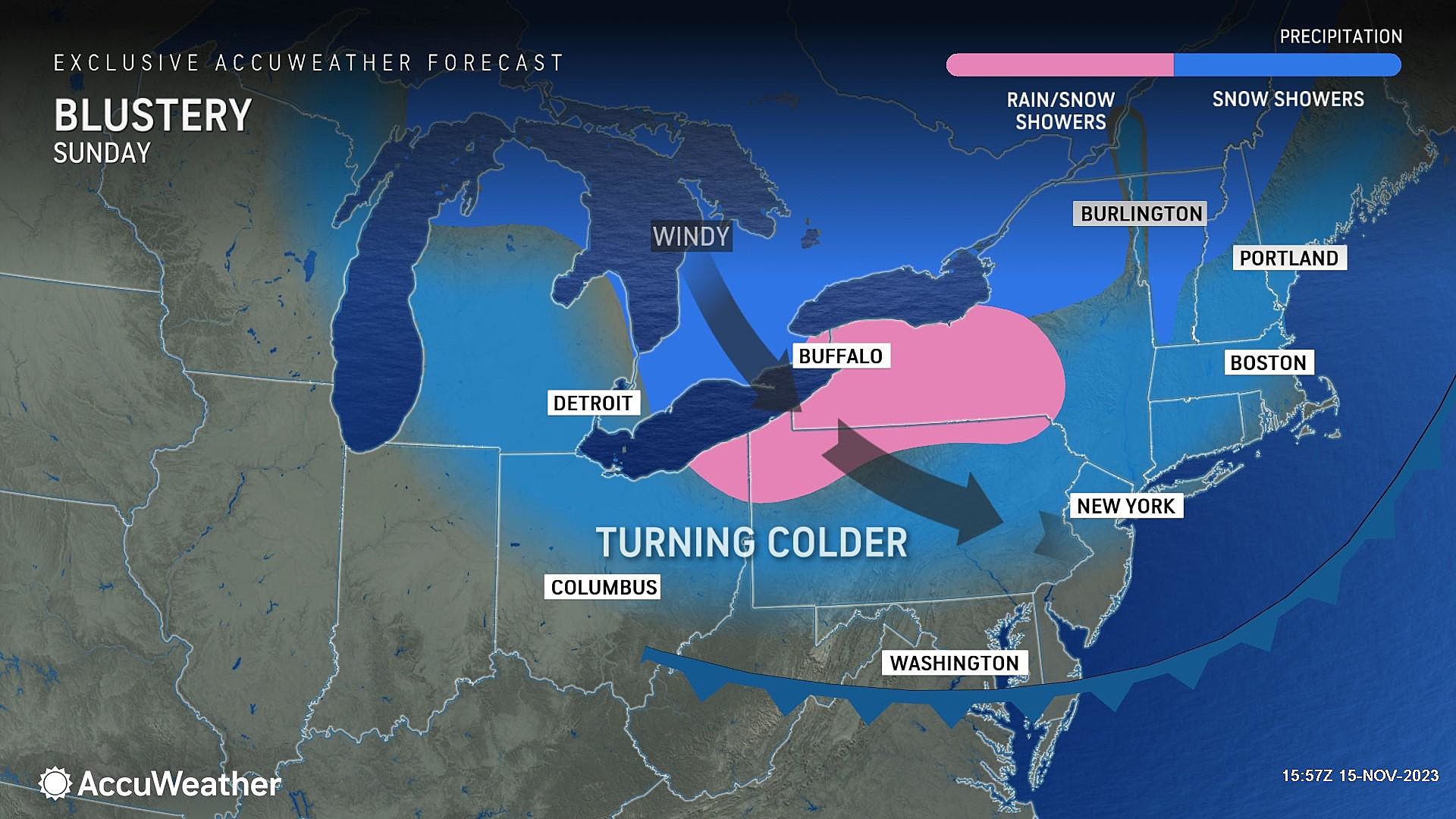
Sunday
Sunny, but blustery. Wind speeds will remain in the "breezy" category — hopefully becoming less gusty than on Saturday.
Morning low temperatures will likely dip to around the freezing mark. High temperatures will only reach the lower 50s. So once again, we will swing to below-normal temps to close out the weekend.
The Extended Forecast
Monday and Tuesday will get even colder, with highs only in the 40s. Feeling rather December-ish again.
And then our attention turns to a storm system set to arrive in the Tuesday-Wednesday time frame. Let me lay out what we know about this soggy setup at this point:
—Model guidance is in good agreement that there will be a storm in our vicinity in the days leading up to Thanksgiving.
—Heavy rain is the biggest concern, on the order of 1 to 2+ inches.
—Gusty winds are also possible, gusting to 40+ mph.
—A quick hit of wintry mix is possible in North Jersey only, for a few hours on the front of the storm. Accumulations and travel issues from this piece should be minimal.
—If you're traveling north into New York State or New England for the Thanksgiving holiday, you may have more significant winter weather issues to contend with.
—Timing is the tricky part. Rain could begin as early as Tuesday morning. It could wrap up as late as Wednesday evening. The forecast for heavy stuff is currently centered on the Tuesday afternoon to Wednesday morning time frame.
This is obviously a very precarious situation for any traveler by road, rail, and especially air. We should start to get a clearer, more definitive view of the situation this weekend. And of course, we will continue to pass along the latest "play-by-play" forecast information as it becomes available.
Thanksgiving snow? When it happened, & the odds in NJ for 2023
Gallery Credit: Mike Brant
Dan Zarrow is Chief Meteorologist for Townsquare Media New Jersey. Follow him on Facebook for the latest forecast and realtime weather updates.
First flakes: When does snow season start in NJ?
Gallery Credit: Dan Zarrow
More From Cat Country 107.3