
The heat rolls on: Wednesday may be NJ’s hottest day of the year
The Bottom Line
In case you're keeping score, Wednesday will be the 4th of six consecutive days in which New Jersey hits 90+ degrees. You know the drill: Dress for the weather, take frequent breaks in air conditioning, and stay extra-hydrated.
Normal high temperatures here in early September are around 80 to 82 degrees. We are easily running 10 to 15 degrees above that benchmark this week. 90s (and even 100s) in September are not unprecedented, but they are unusual. It is also rare for the hottest temperatures of the year to occur in the closing weeks of summer. But here we are.
Widespread 90s will hang on for a couple more days. Then, clouds and rain will push temperatures downward a bit this weekend. But it will be unsettled. And the humidity will remain for another week or so.

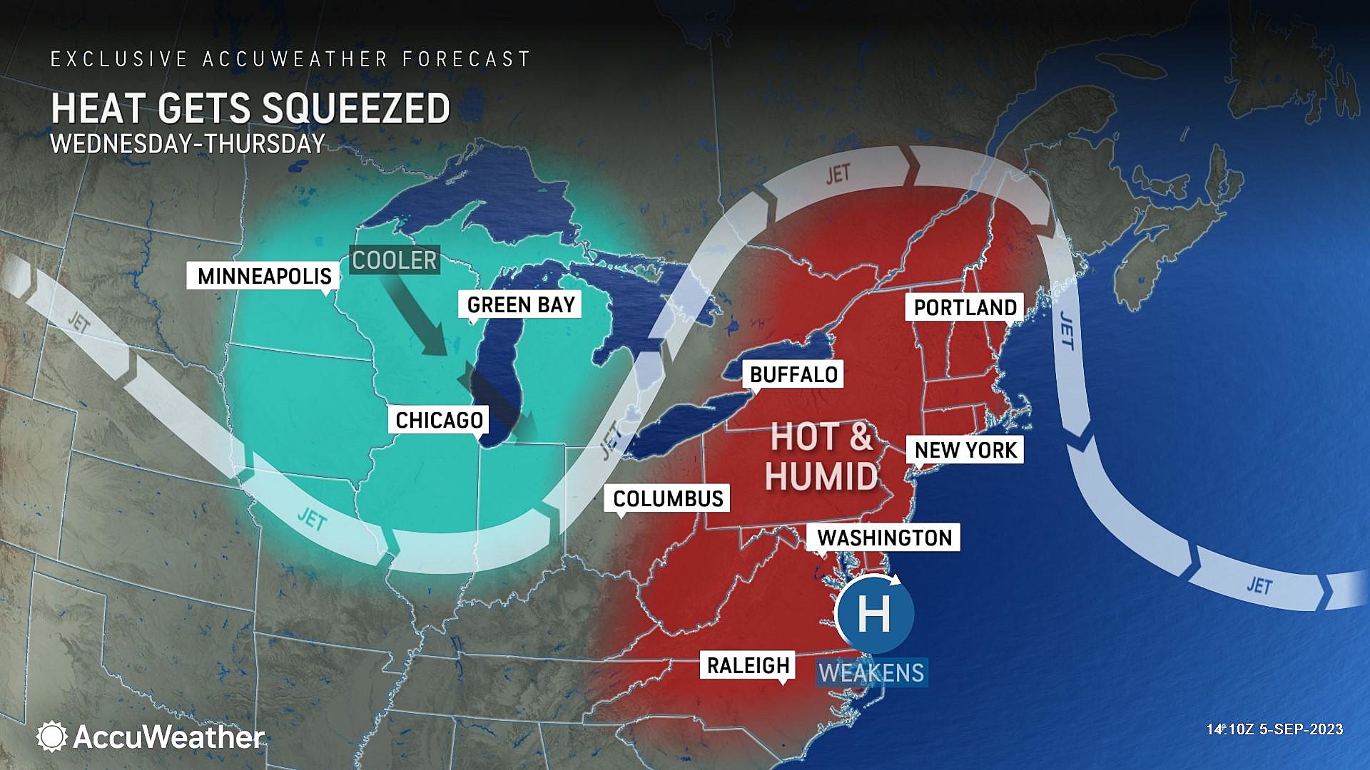
Wednesday
Hot and humid. Period, full stop.
The hazy, blazing sunshine certainly won't make it feel any cooler. Temperatures are starting off in the 70s Wednesday morning. And we'll end up in the lower to mid 90s Wednesday afternoon.
The heat index will max out around 100 degrees. Remember, that's not only the "feels like" temperature. The heat index is our indicator of how heat and humidity affect the human body. When it reaches the triple-digit mark — like it will Wednesday — you really have to take care of yourself to stay safe and healthy.
While record temperatures were broken on Wednesday, those records are probably safe on Thursday. That is only because the record highs for September 6th are higher, in the upper 90s.
A Heat Advisory is once again in effect for most of the state — generally along either side of the NJ Turnpike corridor — until 8 p.m. Wednesday.
The immediate coast will be the "cool" spot in the state, as usual in the summertime. And more good news for the Jersey Shore: The rip current risk has relaxed from High to Moderate, as the wind direction and swell direction turns parallel from the coast. (Rather than pounding it at a perpendicular angle.)
Wednesday night will be a typical heat wave night, muggy and uncomfortable. Low temperatures will only dip into the 70s overnight.
Thursday
Same story, different day. To an extent.
We will be back in the 90s again Thursday. The day will start with sunshine, before some clouds build Thursday afternoon.
There is also a limited chance of rain to talk about Thursday. A few thunderstorms may brush up along the western and northern edges of the state Thursday evening. There is a severe weather risk, but I believe the majority of New Jersey will remain dry and storm-free.
Friday
I am calling Friday the final day of this September heat wave. However, not everyone will hit 90 degrees on Friday. And there is a chance for a couple 90-degree readings on Saturday.
Skies will turn mostly cloudy on Friday, keeping temperatures closer to the 90-degree mark.
Once again, there will be a chance of spotty thunderstorms in the afternoon and evening hours on Friday. And again, the stormy weather looks to predominantly affect northern and western sectors of NJ. (A little more widespread than Thursday's storm activity.)
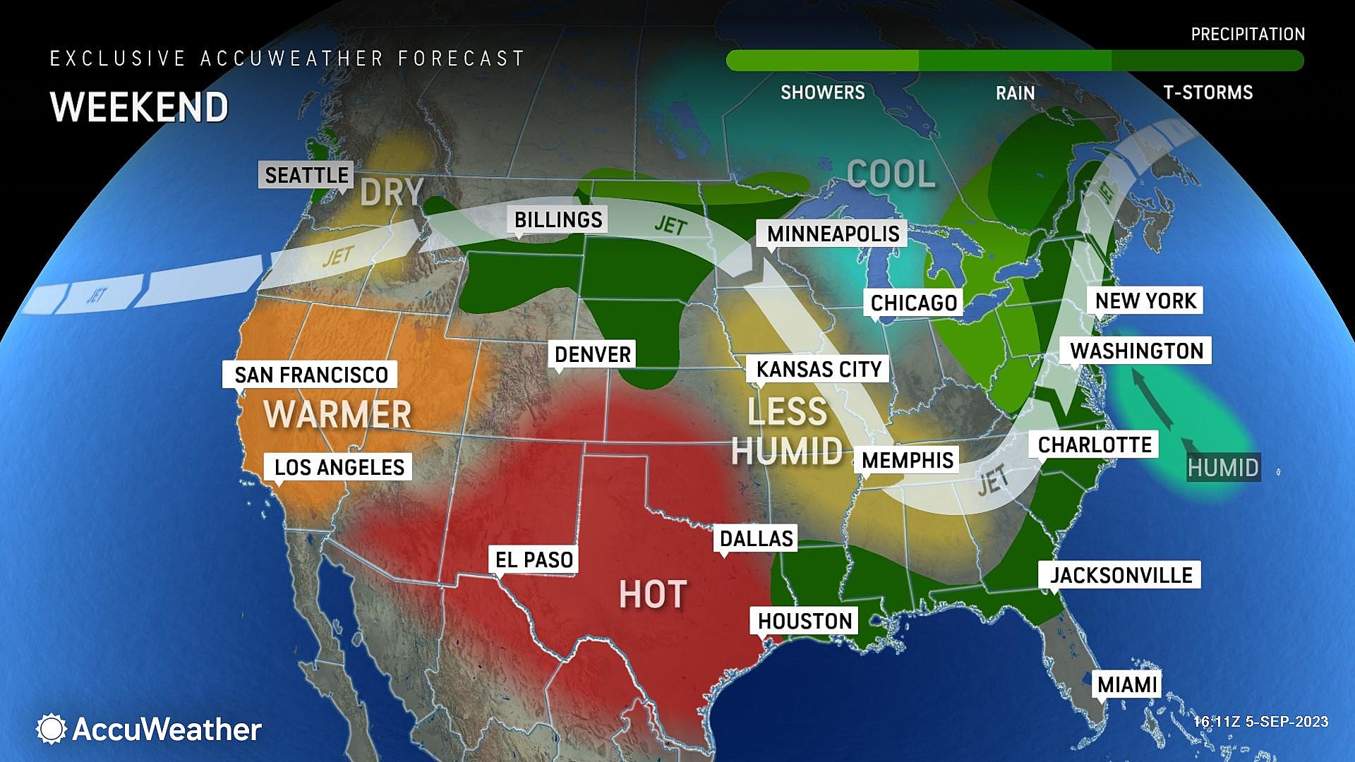
The Weekend
The heat breaks. And widespread rain returns.
It is not going to rain all weekend. In fact, neither Saturday nor Sunday will be a washout. But you will have raindrops and rumbles of thunder to dodge, no matter where in New Jersey you are. (I suspect many outdoor activities will be impacted by the wet weather.) Some of this weekend's rain could be on the heavy side.
As it stands now, the best chance of rain both days will be in the afternoon and evening hours. But I hope to piece together a more detailed, useful timeline over the next day or two.
Saturday will be mostly cloudy, with some sunny breaks, pushing high temperatures into the mid 80s. Sunday looks cloudier and slightly cooler, with highs in the lower 80s. Keep in mind, humidity will still be moderate to high, so it's going to be a sticky late summer weekend overall.
The Extended Forecast
The big headline in the long-range forecast is a cold front modeled to arrive next Thursday. That will drive in rain, followed by a surge of drier, cooler air. If all goes well, the midpoint of September should feel much more seasonable and much more comfortable than the first third of the month.
We are still watching the tropics carefully, as the peak of the Atlantic hurricane season approaches. Tropical Storm Lee is currently centered about 2,500 miles southeast of New Jersey, in the middle of the Atlantic. Still way out there. While the latest forecast pulls Lee away from the U.S. East Coast next week, that is not a sure bet. This is a storm track worth watching.
NJ’s dry towns: No stores to buy wine, beer or booze
Dan Zarrow is Chief Meteorologist for Townsquare Media New Jersey. Follow him on Facebook for the latest forecast and realtime weather updates.
Most popular town names that NJ shares with the rest of the country
More From Cat Country 107.3


