How South Jersey Almost Went to War (Kinda) With Delaware in 2008
This is an absolutely fascinating story about how a decision made hundreds of years ago by the King of England started a feud between South Jersey and Delaware in 2008.
And, as elected officials sometimes get when state pride comes into play, a symbolic "war" (on paper -- not in a literal sense) was waged right in our own backyards over a small piece of land.
When you picture a map of New Jersey, you pretty much think of us as the state that has the ocean on one side, the Delaware River on the other, and we're south of New York. Whatever is between those points is the Garden State.
Well, not exactly.
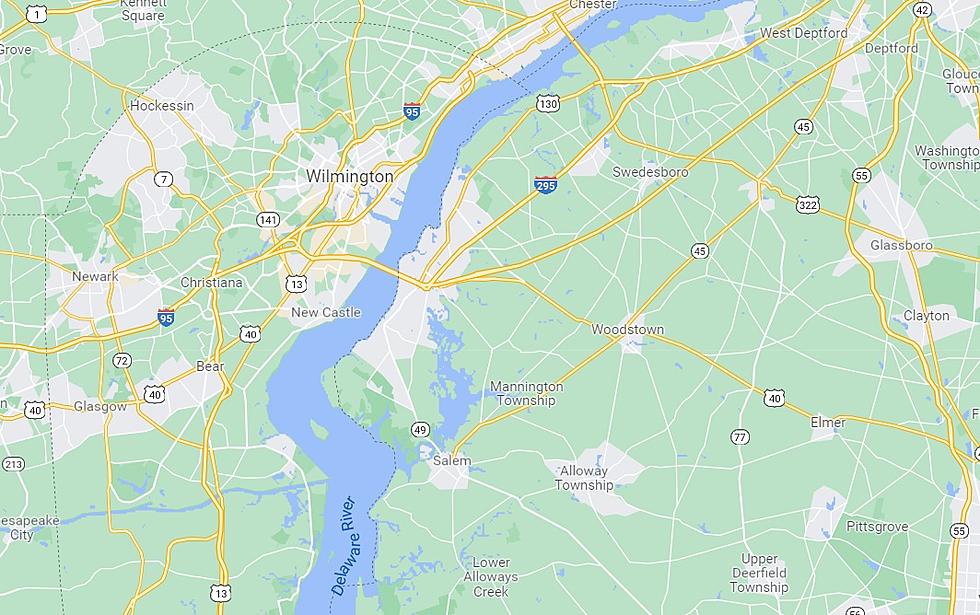
You see, in Salem County, there are two areas of land that are east of the Delaware River (on the Jersey side) that are owned by the State of Delaware.

The first is a plot of land next to Finn's Point National Cemetery and Fort Mott State Park. That dotted line is the state line and everything to the left of it is Delaware.
The second is a little less significant but still important.

Next to the Salem and Hope Creek Nuclear Power Plants, Delaware claims a small part of Artificial Island.
Honestly, neither one of these plots of land is hugely important to either state, but they have caused some issues.
For example, if a crime was committed in either of those areas, police officers from Delaware had to drive over and investigate it. And that happened in the past.
NJ.com reports back in November 1987, a 45-year-old hunter's body was found on the Delaware side of the state line on the Jersey side of the river. The Pennsville Police Department, which is right there, had to contact the Delaware State Police, who took an hour to get to the scene.
Shortly after that, officials in Delaware gave permission for Pennsville cops to patrol the area.
How did all of this happen?
You can thank the King of England hundreds of years ago. When Delaware was established, the King drew a 12-mile circle around New Castle, DE, to determine the (future) state's boundaries. Instead of the Delaware River being split down the middle between the two states, the state line is actually right along the New Jersey shoreline. Over time, dirt accumulated in two spots, thus giving Delaware a claim to land on "our" side of the river.
How did a "war" almost start?
Long story short, in 2008, the Garden State had plans to build a petroleum pipeline, and a legal battle ensued that went to the Supreme Court.
As the two states battled a public relations war, some South Jersey lawmakers threatened economic sanctions against the First State and even jokingly wanted to bring the Battleship New Jersey down (which had been decommissioned 17 years earlier and obviously not physically possible).
Delaware, meanwhile, responded symbolically by calling up the National Guard to defend their turf.
Luckily, calmer heads eventually prevailed.
That is until social media came along.
20 things that shock people after they move to South Jersey
Gallery Credit: Chris Coleman
Website Ranks 11 Towns in South Jersey That Suck the Most
Gallery Credit: Chris Coleman
More From Cat Country 107.3