
Bundle up, NJ! How cold it will get and how long it will last
The Bottom Line
The arctic blast is on. Grab the heavy winter coat, folks. While you may not need it Friday morning, you will definitely want it later on. Also, since very cold air is also very dry air, stay hydrated and keep the lip balm and moisturizer handy too.
As of this writing (6 a.m.), cold air has started to leak into New Jersey. Along with it comes a strong northwest wind and a few flurries. Friday will be a blustery day, with temperatures tumbling through the afternoon.
Friday night is going to bite, as wind chills descend into the "danger zone". Saturday will be frigid, with lighter winds — thermometers will be stuck below freezing all day.
And then it's all over. Temperatures bounce back into the 40s — above normal — for Sunday and beyond.
Friday
A strong cold front is sagging southward through New Jersey on this Friday morning. As it passes by, you will notice three things:
1.) A brief snow shower or flurries
2.) Wind kicks up, gusting to 30+ mph
3.) Temperatures will start to drop
We already hit our daily high temperature early Friday morning, in the 30s. We will descend into the 20s by late morning. And then teens to lower 20s by late afternoon.
Remember: That's what the thermometer will say. The wind will make the air feel even colder and more biting.
Weatherwise, aside from cold and wind, there won't be much else to worry about. Besides a few flurries, sunshine should dominate the sky.

Friday Night
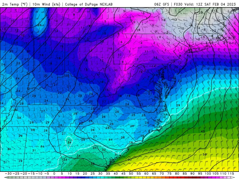
After sunset, things get dicey. Thermometers will continue tanking, into the teens and eventually single digits. My forecast calls for low temperatures between 1 and 10 degrees by Saturday morning. Not quite in "record low" territory, but close.
In addition, the wind will stay elevated all night. So those bitter gusts will still be in the 30+ mph range. That gives us wind chills below zero for several hours overnight. Some spots could see wind chills below -10 degrees.
This is dangerous cold. You need to limit your exposure to such extreme cold and wind. And if you do head out on an "arctic expedition" Friday night through Saturday morning, you'll want to layer up and cover up as much exposed skin as possible.
A Wind Chill Advisory goes into effect for Sussex and western Passaic counties at 5 p.m. Friday, and lasts until 9 a.m. Saturday. That will be the coldest corner of the state, with a wind chill as low as -20. Ouch!
Saturday
After sunrise Saturday, the wind will dial back a bit. That is good news.
We will also see plenty of sunshine throughout Saturday. More good news.
But temperatures will be frigid, stuck below freezing all day. Afternoon highs will only reach the mid 20s. Note: This will not be the coldest day of the season so far. That honor belongs to Christmas Eve, December 24th, when highs were only in the teens.
Warmer air will start to penetrate our atmosphere Saturday night, so temperatures will start to rise slightly.
Sunday
Just like that, the cold snap is all over. Temperatures will rapidly climb into the mid 40s or so by Sunday afternoon. Much more comfortable. And more typical of early March than early February.
Sunday will not be a perfect day though. Skies will turn mostly cloudy to overcast. And some sprinkles and spritzes may clip the state around the late afternoon to evening hours.
Monday & Beyond
The only weathermaker showing up in the forecast models for next week is a weak cold front arriving Wednesday morning. At the moment it looks to bring only some rain showers to town.
Temperatures will hold steady around the 50 degree mark throughout next week, with mixed cloud cover.
Any threat for wintry weather is more than a week away. We'll see if the pattern changes enough around the midpoint of February to allow colder, more active weather to take hold.
Stay warm out there this weekend!
Dan Zarrow is Chief Meteorologist for Townsquare Media New Jersey. Follow him on Facebook or Twitter for the latest forecast and realtime weather updates.
New Jersey's Top 8 Weather Stories of 2022
These are the Hottest Pop Concerts Happening in Philadelphia in 2023
More From Cat Country 107.3


